|
Témaindító hozzászólás
|
2007.09.20. 20:34 - |
A XXI. század közepére eltűnik a tó |
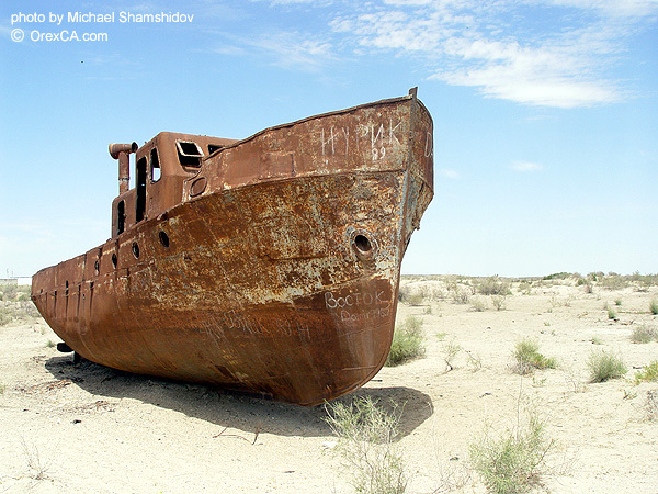
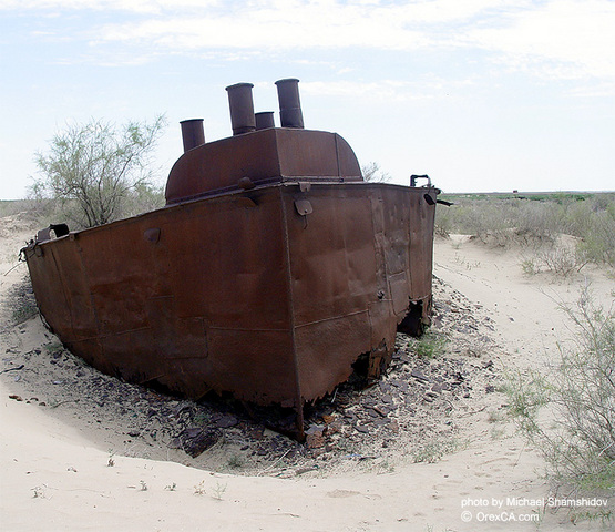
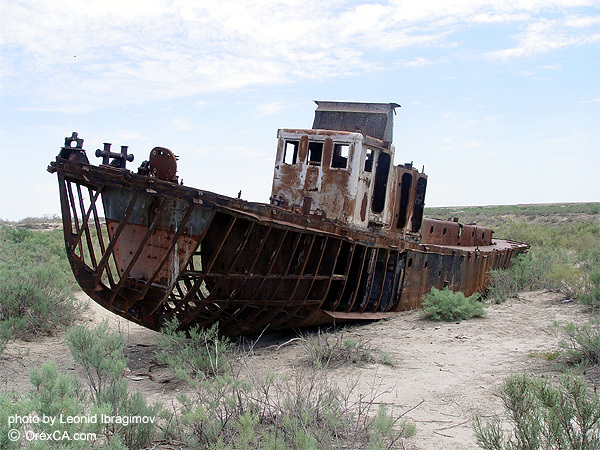
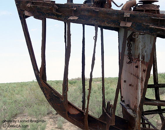
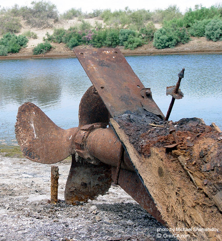
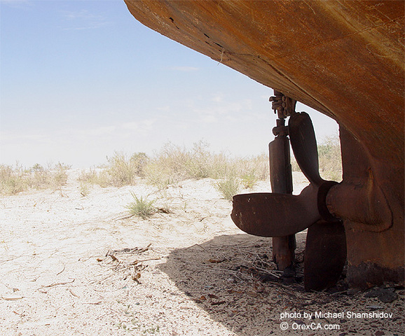
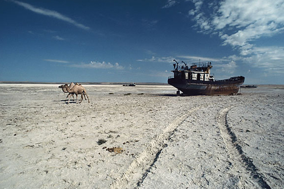
Megfeneklett hajók Uvarazmiyában |
James Rupert
Washington Post’s foreign staff
How the Soviets Destroyed a Sea in Thirty Years
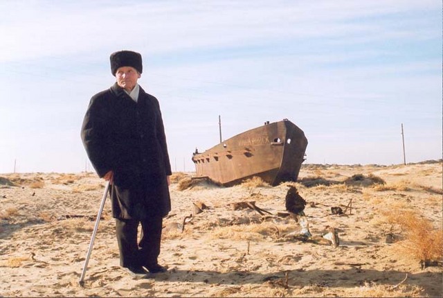
A stretch of desert that used to be the Aral Sea is shown by Abdulkarim Teleyuov, the former Communist Party secretary in Muynak, Uzbekistan. Fish is now imported more than 2,000 miles by rail and truck from the Baltic Sea.
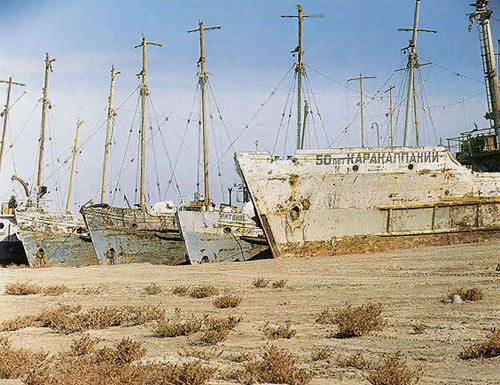
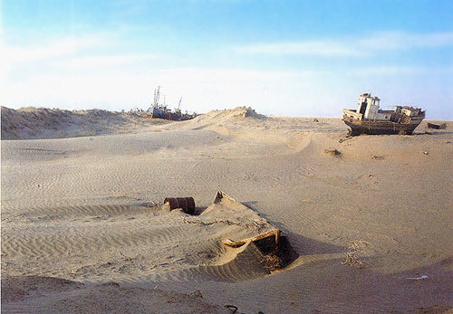
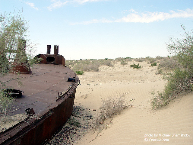
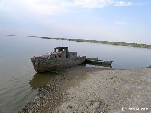
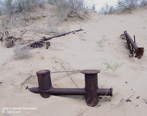
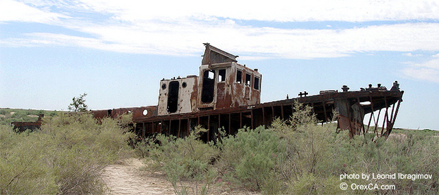
Muynak, Uzbekistan - In this frightened town, life has always meant fishing. Men’s faces are leathered by lifetimes on the Aral Sea; their arms thickened by the weight of countless nets hauled from the waters. The women’s hands are scarred from millions of the slices and chops that remove heads and fins from wet, rough fish at the cannery. In Muynak, there are boats and docks. There are anchors and chains. But there is no sea.
The nightmare began imperceptibly, in the 1960s. Muynak and other towns on the Aral were thriving, hauling 160 tons of fish each day from its shimmering waters. The ovens at Muynak’s massive cannery burned around the clock, cooking sturgeon and carp. The Aral was the world’s fourth-largest lake, bigger than West Virginia, and the live, pulsating heart of a forested oasis amid Central Asia’s dry steppes and desert.
But, by inches at first - then by yards and miles - the Aral began to shrink away from the people who needed and loved it. It receded from the dock-, then from the harbor. Horrified, the townspeople dug a channel across the sands, trying to keep a hold oil the fleeing lake. In one of mankind’s most tragic devastations of the planet, the Soviet Union for 30 years has been diverting the Aral’s feeder rivers into the steppes and deserts to irrigate what was to have been the world’s largest cotton belt. Instead, it has destroyed the Aral and stranded this fishing town on the bitter sands of a new desert. Muynak has found a way to survive for the moment, but the moment will not last long. The fish cannery in the desert now packs fish hauled by rail and truck more than 2,000 miles from the Baltic Sea. To get the tin for its cans, the cannery barters scrap iron. It has sent a crew of former fishermen out onto the lakebed to chop up the town’s former fishing boats, which lie rusting in the sand dunes where the lake left them behind. The boats will soon be chopped and sold - and the Baltic suppliers of frozen fish may soon demand hard cash, instead of the vegetable oil the cannery is currently bartering. “We are looking for new ways to keep ourselves working,” said Dowlbai Kairniyazov, a plant manager. He speaks optimistically of getting more fish supplies from the Caspian Sea or from local lakes. The decisions of Soviet authorities - unquestioned for seven decades -had nearly unlimited opportunities to create environmental disaster. With its grandiose cotton plan in Central Asia, it ruined an entire watershed -drying up 75 percent of the Aral; making the region’s weather more extreme; polluting and salinating thousands of miles of rivers and vast tracts of farmland; sickening millions of Central Asians with overuse of pesticides, fertilizers and defoliants; and destroying the region’s natural economy. There is worse news, While a single Soviet state created this disaster, it is now left to five newly independent and impoverished Central Asian republics to grapple with it. Travel and interviews in Central Asia during the first 10 months of the these republics’ independence suggest that very little will be done in the foreseeable future - and that the people of Muynak and the Aral region are condemned to living poor, shortened and sickened lives.
The Confidence Of Absolute Power The destruction of the Aral began in Moscow in the 1950s, when Soviet economic planners decided, with the confidence of people wielding absolute power, to order the transformation of Central Asia’s dry lands into the world’s largest cotton belt.
The planners’ imagination was immense, their logic simple. They would divert the vast waters of the Amu and Syr rivers into thousands of square miles of adjacent desert and steppe.
The inevitable decline of the Aral would pose no problem. According to some versions of the proposal, the lakebed itself would be turned into a zone of cotton and rice farms. “They decided that the sea was not necessary…that the value of the cotton would be greater than the loss of the fish,” said Yusup Kamalov, an environmentalist and energy researcher in the Aral region who reported seeing maps of the plan.
Beginning in 1960. the state built dams and reservoirs on the Amu and Syr rivers. It dug canals to carry their waters into the desert, razed riverine forests and built state-run cotton farms in their place.
While Moscow ordained the cotton plan, the political elites of the republics -especially the powerful political bosses of Uzbekistan - were able to direct much of the spending. They channeled money, jobs and reservoirs into favored constituencies on upstream sections of the rivers. The result is visible on airline flights over Central Asia. Upstream, around the Uzbek capital, Tashkent, and the influential Fergana Valley, tight networks of irrigation canals and constellations of reservoirs glint in the sun.
Downstream, in the politically weak Karakalpak region that includes the southern Aral Sea, water is scarcer - and polluted with the upstream’s agricultural runoff. Ethnic Karakalpaks, including Abdulkarim Teleyuov, a longtime Communist Party leader in Muynak, accuse the powers in Tashkent of needlessly hoarding the Aral’s water. Teleyuov ticked off the names of upstream reservoirs that lie said hold 70 percent of the annual flow that the Aral should naturally receive.
“This year we got enough water from the Amu to fill” some local lakes left behind by the Aral’s retreat arid “help us raise fish,” said Teleyuov. “But in many years, we get no water…We never know from one year to another what we might receive, so we cannot plan for either fishing or farming,” he said.
Uzbek Water Resources Minister Rim Giniyatullin has told reporters that I Uzbekistan uses its water efficiently-that there is nothing extra to send downstream to Karakalpakstan and the Aral.
But the leading western specialist on the Aral Sea disaster appears to disagree. Philip Micklin, a geologist at Western Michigan University, has estimated that as much as 40 percent of the water diverted from the Aral’s rivers is lost before reaching the fields it is meant to irrigate. The water evaporates from reservoirs or seeps into the ground from thousands of miles of unlined canals dug through porous soil.
The inefficient use of irrigation water is not merely wasteful; it can be killing to the land. Where unlined canals or over irrigated fields seep water, the under ground water table rises, sometimes to the surface. As it does so, it often accumulates subterranean salts that are left to encrust and ruin farmland.
During the 1960s and ’70s, the Moscow planner-, calculated the amount of cotton that their newly irrigated lands should produce and ordered Central Asia to deliver it. The entire economy warped itself around the goal of “fulfilling the plan.” Students were sent from school each year into the fields to pick the cotton with the workers. People recalled work brigades that, pressured by their bosses, falsified figures, soaked their cotton with water -and even emptied their cotton-stuffed mattresses - to add to the tonnage.
Under such pressure to produce, state run farms dumped as much as 530 pounds of fertilizer per acre on the fields each year, compared with the Soviet average of 27 pounds. Defoliants (used to ease the harvest by stripping leaves from the cotton plants), fertilizers and pesticides used on cotton applied an average of 48 pounds of poisonous chemicals to each acre, according to Soviet press reports in 1988.
For decades, clean water from the rivers upstream has washed across these fields heavy with salt, fertilizers and pesticides -and drained back to the rivers to irrigate more fields, or serve as drinking water, downstream.
Upstream, Downstream In visits this past spring to towns upstream and downstream on the Amu River the contrasts in people’s lives were stark. In Termez, 680 miles upstream from Muynak, people worried about the collapse of the Soviet economy. Still, virtually everyone interviewed said they had the best standard of living in Uzbekistan - maybe in the former Soviet Union. The Sunday market displayed piles of fruits and vegetables watered from local reservoirs. Seen from a plane, the upstream valleys of southern Uzbekistan and Tajikistan are a patchwork of green fields laced with silvery irrigation canals and ditches. Tomatoes, cucumbers, potatoes and other produce, made into local dishes covered the dinner table in Tahir Rakhrnanov’s apartment. “We harvest many of those twice a year,” he said. “There aren’t many places in the (former Soviet) Union that can do that.”
Downstream, the Amu delta looked like a planet hostile to life - the sort of place where characters in a Steven Spielberg film are to have their mettle tested.
Even in springtime, the place seemed barren. Roads stretched through gray-white lands, always toward a horizon fogged by curtains of blowing, salty dust whipped up by winds off the Aral’s exposed seabed. Evaporating ground water left collars of salt crust around the bases of tree trunks and telephone poles,
Even the weather is unearthly. The Aral used to create a moderate microclimate, curbing the extremes of summer and winter. But now the heat often rises in the summer to more than 100 degrees, with stinging salt storms that sweep in off the seabed. Farmers say they have lost as much as two months from their growing season.
“At least 80 percent of Karakalpakstan’s land is salinized,” said Sabir Kamalov, president of the Karakalpak Academy of Sciences. “Its productivity is cut (by) anywhere from 20 percent to 70 pet-cent.”
Near the delta town of Chimbai, Turehbai Telegenov, a 37-year-old unemployed accountant, struggled against the odds to coax vegetables out of a half-acre plot of land. Twenty-five years ago, he said, when the Aral still was nearly whole and before the Amu river waters were so heavily salted, “we used to grow every thing here.
“Ten years ago, we still had woods and apple orchards and grapes,” he said, but the rising water table drowned them from the roots.
As Telegenov’s four children played in the salt-crusted dirt, he and his wife struggled to erect a reed fence around the field. Telegenov said lie would use well water, which is not as saline as that of the irrigation canals, “to wash the salt ... most of it ... out of the field. Then I will use manure to improve the soil and we will grow tomatoes and cucumbers for our family.”
“Everybody is Sick” Karakalpakstan’s dirty downstream water is used not only for farming, but for drinking - the major cause of what health officials in this region say are epidemic levels of hepatitis, cancers and anemia.
One Sunday morning, at the weekly bazaar in Nukus, the Karakalpak capital, Aikhan Kulsiyityeva, 69, sat on the pavement behind her children’s clothes for sale and lectured a visitor on the difficulties of life in Karakalpakstan.
“Everybody is sick. Our legs and heads hurt. Fifty percent of the people in Karakalpakstan are sick,” she said.
“There is no clean water. If you make tea and you pour milk into it, it all curdles from the salt,” she said. “You shouldn’t eat or drink what we have here. We drink green tea and try to make it very strong. But it’s salty, too.”
In Nukus, chlorine is added to the water, which is taken from nearby canals. In smaller towns, “we take the water from the canals or the tap and let it stand for three or four days,” to let the sediment settle out, said Yusupbai Ishanov, an agricultural researcher in Chimbai. “It’s not clean, but you can drink it.”
In 1979, the Karakalpak immunological service counted 32 percent of drinking water samples taken in the region unfit for human consumption. In 1989, the agency’s director said, the figure was 83. 2 percent. The water is heavy with chlorides, sulfates, pesticides and heavy metals, health workers in Nukus said - and those same compounds are measure(] in locally grown food - and the breast milk of nursing women.
Oral Ataniazova, director of Karakalpakstan’s institute of women’s and children’s medicine, said she advises wealthy women not to breastfeed-but to make infant formula with water that has been boiled to kill germs, then frozen to reduce minerals. With village women, Ataniazova said, she tells them simply to breast-feed, because they lack the fuel and freezers to clean their water. Infant mortality is nearly 100 per thousand in some districts of Karakalpakstan. That rate, 10 times the U. S. average, is similar to those of Nigeria and Uganda.
Unlike the European peoples of the former Soviet Union - the Balts and Ukrainians and Russians who marched and voted and demonstrated for an end to communist rule - the Central Asians have not channeled their discontent into political demands. They continue to be ruled by authoritarian bureaucracies that simply have dropped the label “communist.”
Especially here in relatively isolated anti unchanged Karakalpakstan, it does not even seem to occur to most people that they can change their political system. In any case, said Sabir Kamalov, “We cannot fight Tashkent.”
Kamalov and his son, Yusup, the, energy researcher, have been met officials of all five Central Asian republics, speaking of the need to reach a regional agreement on the sharing of river waters that will include the goal of sending more clean water downstream to the Aral. While officials from some republics have been receptive, “We cannot find a common language with the Uzbek government,” he said. The people making decisions there “have been in charge of their water policy for a long time.”
People seem more exhausted than angered by their plight. “The illnesses of our people sap our strength,” said Sabir Kamalov. “I would cry but I have no more tears. In five years, we won’t have any more emotions left at all.” |
Az évezredek óta tartó kiszáradási folyamatot az avarok egykori földjén a szovjetek jelentősen felgyorsították |
Avarföld ma: a leninizmus durva beavatkozása teljesen tönkretette az egykor virágzó, halban gazdag vidéket. Kb. 40 évig lehet még halászni... |
|
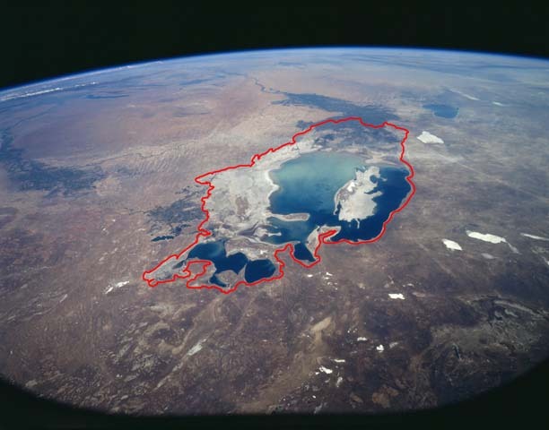
Az Aral-tó (kazahul Арал Тенізі / Aral Tengizi, üzbégül Orol dengizi, oroszul Ара́льское море / Aralszkoje more) Kazahsztán és Üzbegisztán határvidékén, a Kaszpi-tengertől keletre, a Turáni-alföldön elhelyezkedő lefolyástalan sóstó. 1960-ban még a Föld negyedik, ma nyolcadik legnagyobb tava. A tavat tápláló folyók, az Amu-darja és a Szir-darja vizének öntözésre való felhasználása, valamint mikroklimatikus változások következtében az 1960-as évektől a tó vízszintje jelentősen csökkent. Napjainkra egyik folyó sem éri el a két részre szakadt, folyamatosan pusztuló Aral-tavat. Az ökológiai katasztrófa sújtotta egykori tó egyes értelmezések szerint a globális klímaváltozás hatásainak és következményeinek elrettentő példája.
Az Aral-tó Kazahsztán és Üzbegisztán határvidékén, a Turáni-alföldön fekszik. Nyugatról a sivatagos Usztyurt-fennsík (Uszt-jurt) 200 méteres magasságba törő szirtjei, keletről a Kizil-kum sivatagos vidéke (és ennek északnyugati része, a Golodnaja-sztyepp) határolja. Északon, a Szir-darja deltájánál a tótól elkülönült, de azzal összeköttetésben állt a Kis-Aral-tó. Az 1960-as évekig délről az Amu-darja, északkeletről a Szir-darja táplálta (56 km³/év), ami a csapadékmennyiséggel (9 km³/év) kiegészülve pótolta a tó hatalmas párolgási veszteségét (65 km³/év). A régió éghajlata kontinentális, a júliusi középhőmérséklet 25-26 °C, a februári –2-2 °C, az évi csapadékmennyiség 110-150 milliméter. Az 1960-ban 68 900 km²-es kiterjedésű, északkelet–délnyugati tengelyű tó hossza 492, legnagyobb szélessége 290 kilométer volt, délen és keleten öblökkel tagolt partvonalának hossza pedig elérte a 3000 kilométert. Átlagos mélysége 16 méter volt, de legmélyebb pontján elérte a 63 métert. A tavon több mint 1100 kisebb-nagyobb, összterületüket tekintve 2200 km²-nyi sziget volt. Az Aral-tó vizének sókoncentrációja az 1960-as 9,6-10,3‰-ről 27-30‰-re emelkedett.1
A késő neogénben tektonikus törésvonal alakult ki az Aral-tó helyén, de az ennek mentén keletkezett mélyedés még a pleisztocén végén is száraz medence volt. A későbbi földtörténeti korokban a Szir-darja töltötte fel a süllyedéket, s az alapvetően száraz időszakban kialakult egy a maival nagyjából megegyező területű tó. A holocénben drasztikusan megváltozott a korábban a Kaszpi-tengert tápláló Amu-darja folyása, s vizét immár a leendő Aral-tóba vezette. A klimatikus változások is melegebb, csapadékosabb éghajlatot eredményeztek, s az Aral-tó elérte a XX. században ismert kiterjedése kétszeresét, területe meghaladta a 150 ezer km²-t, a vízfelszín tengerszint feletti magassága elérte a 75-80 métert. Az i. e. IV. évezredben az éghajlati viszonyok ismét szárazabbra fordultak, s a tó mintegy 30 méternyit apadt, majd az i. e. I. évezredre lassan a 31--35 méteres tengerszint feletti magasságig, azaz nagyjából napjainkbeli kiterjedésére apadt, de a vízfelszín csökkenése ezt követően sem állt meg. Az i. sz. XVI. századra az Amu-darjának a Szarakamis-tavat tápláló ága elapadt, így teljes vízmennyisége az Aral-tóba folyt, amely ezzel elérte a XX. században ismert kiterjedését.2
A tavat Kr. e. II. századi kínai források említik először Északi-tenger néven, a rómaiak viszont Oxusi-mocsárnak (Palus Oxiana) hívták (az Amu-darja latin neve Oxus volt). A X–XII. század mohamedán geográfusai már jól ismerték a hatalmas állóvizet(Horezmi-tó) és vidékét, a későbbi évszázadokban azonban már a vízszint apadásáról maradtak fenn írásos említések. Az Aral-tó újbóli gyarapodását követően, a XVII. században Khíva kánja, Abu al-Gházi (1603–1664) használta először a türk aral (’sziget’) szót az Amu-darja torkolati vidékének leírására, s a XVIII. századi európai térképeken már mint Aral-tó jelent meg. A XVII. században a Khívai Kánság területéhez tartozott a vidék, később a Kokandi Kánság és a Buharai Emirátus uralta, mígnem 1847-ben Oroszország katonai helyőrséget létesített a partján, s 1873-ban igazgatásuk alá vonták a vidéket.
Már az 1870-es évektől sokat fáradoztak a sivatagos környék öntözésének megoldásán, gátak közé szorították a Szir-darját, és a két folyó vizét elvezető kisebb csatornákat építettek. A mezőgazdasági termelés javát szolgáló csatornázás veszélyeire már a XIX. század végén felhívták a figyelmet orosz tudósok (pl. A. I. Vojejkov klimatológus). Ennek ellenére a szovjethatalom éveiben további csatornákat építettek, s a második világháborút követően megszületett a terv a Golodnaja-sztyepp és Türkmenisztán rizs-, gyapot- és gyümölcsültetvényeinek vízellátását megoldó csatornarendszer kiépítésére. Az Amu-darját a Kara-kum sivatagon keresztül a Kaszpi-tengerrel összekötő 1300 kilométeres Türkmén-főcsatorna (vízfelvétele 8--14 km³/év), valamint az Amu–buharai-csatorna (10 km³/év) az 1950-es évek végére készült el. Noha az Aral-tó vízutánpótlását ezzel jelentősen veszélyeztették, és az első jelek 1961-től megmutatkoztak, a későbbi időszakban további csatornák épültek: Déli-Golodnaja-csatorna (11 km³/év), Karsi-csatorna (5 km³/év). Az öntözött területek nagysága 1970-re elérte a 74 ezer km²-t, de az Aral-tó pusztulása ekkor már megállíthatatlannak látszott.3
2004-re az Aral-tó elveszítette korábbi területének 75, vízmennyiségének 90%-át, a korábbi partvonal mentén fekvő települések több tucat kilométerre kerültek a víztől; így például a korábbi Aralszk (ma Aral, Kazahsztán), Mujnak (ma Mo’ynoq, Üzbegisztán). 1961-től évenként mintegy 50 centiméterrel apadt a tó, egyedül a csapadékosabb 1969-es, 1970-es és 2003-as években állt meg a vízszint csökkenése.4 Az 1980-as évektől a kikötői infrastruktúra használhatatlanná válásával a személy- és teherhajózás, valamint az egykor jelentős, évi 50 ezer tonna halat jövedelmező halászat is megszűnt a tavon. Az 1950-es években leírt gazdag ökoszisztéma (benne endémikus fajokkal) java része kipusztult.5
Egyes vélekedések szerint az Aral-tó vízcsökkenéséért javarészt az emberi tevékenység felelős. Bár a tavat tápláló folyók befogása a környező rizs- és gyapotföldek öntözésére valóban nagymértékben hozzájárult a tó gyors kiszáradásához, alapvetően a mikroklimatikus változások okolhatók az Aral-tó kiszáradásáért. A globális felmelegedés következményeire figyelmeztető környezetvédők az Aral-tó példájában az emberi tevékenység nyomában megváltozott természeti környezet riasztó példáját látják, s az emberiség jövője szempontjából aggasztó jelként értékelik az Aral-tó kiszáradását, amely ráadásul nem is egyedülálló napjainkban (hasonló folyamatok zajlanak a Holt-tengerrel és a Csád-tóval is). Ugyanakkor a geológusok arra hívják fel a figyelmet, hogy ehhez hasonló ökológiai katasztrófák a múltban is előfordultak, amelyek nyomán tavak, beltengerek tűntek el a föld színéről, s nem hagyhatók figyelmen kívül a Turáni-alföld sajátos geológiai viszonyai, ún. paleovaribialitása sem.6
Az 1990-es években indultak meg a kutatások. A helyzet kialakulásáért felelős okok feltárása és esetleges vészforgatókönyvek kidolgozása érdekében végzett munkát az International Coordination Water Commission in Central Asia (ICWC) és az International Aral Salvation Foundation fogja össze.
A klimatikus változások mellett a szovjet korszakban kiépített, nem kellőképpen szigetelt csatornák minősége is okolható a krízisért. A két folyó vizének 30--70%-a elfolyik a sivatagba, ennek dacára a csatornák máig működnek, mert vizük szükséges a legfőbb üzbég exportcikk, a gyapot termesztéséhez.
Mára a tó két részre, az Északi- és a Déli-Aral-tóra szakadt, de nemsokára a déli tó is két további részre fog válni. 2005 augusztusában már megépült egy gát Kazahsztánban az északi és a déli tó közé, és így az északi medencében a vízszint 8 méterrel emelkedett a negatív rekordszint fölé. A szegényebb Üzbegisztán költségvetéséből nem futja a déli medence vízszintjének megemelésére, de ha az északi medence visszanyeri régi vízszintjét, a tervek szerint engednek át vizet a délibe is.
További lehetséges megoldások:
· a csatornák vízszigetelése (ma is csak a 12 százalékuk szigetelt)
· sótalanító telepek létrehozása
· kisebb vízigényű gyapot termesztése
· a Pamír gleccsereinek leolvadása miatt keletkezett víz Aral-tóba vezetése
· a Volga vagy Ob folyók vizének idevezetése
1 Aral-tó, in Magyar nagylexikon; II. köt., Akadémiai, Bp., 1994, 274. o.
2-6 Peter O. Zavialov, Physical oceanography of the dying Aral Sea; Springer, Berlin, 2005, 8–10., 50., 1., 1–2. o. |
A vízfelület régen – és ma
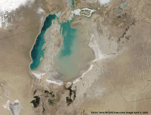
A deszikkáció nyomai madártávlatból |
 |
Petter Hveem
MSF Director of Communications, Norway
The Aral Sea disappears while tuberculosis climbs
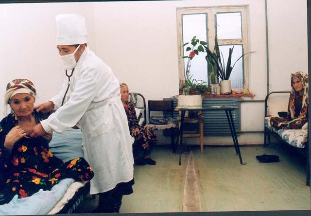
The rate of infection here is among the highest in the world. In Uzbekistan about 13 percent of new cases are multi-resistant, while among those patients who have been treated previously for tuberculosis, 40 percent have MDR-TB. This type of tuberculosis hits harder here than most other places in the world.
A coughing woman stands outside the tuberculosis sanatorium supervised by Médecins Sans Frontières (MSF) in Nukus in Uzbekistan. The hospital was started and designed in 1988, and is a grey landmark building of the Soviet era.
People do not want to have anything to do with us, says a young patient. They say there is no cure for the disease. When asked about the future for the 1.5 million inhabitants of the autonomous republic of Karakalpakstan in Uzbekistan, another patient answers: We are waiting for the water. They are living more or less in a semi-desert, where the temperature can drop to about minus 20 degrees Celsius in the winter and go up to +40, even +50 degrees during the summer. The area is flat and bare with brown bushes as far as the eyes can see, with just a few industrial sites and one or two dromedaries. Beyond that there is the semi-desert.
The Aral Sea is sinking
The shrinking Aral Sea is further north. Aral means island, and the lake now lays sadly alone in the desert. It was not always like this; The Aral Sea was once the 4th largest in-land body of water in the world, and teeming with life. Now it is down to a fourth of its former size, and 10th place on the list.
The ruined lake shows us the megalomania of man in his attempt to tame nature. In order to irrigate the cotton and rice fields in this dry region, the Soviet Union built irrigation channels from the river of Amu Darya. The river was known back through history to the times of Alexander the Great, and was the biggest river in Central Asia, broader than the Nile. Now it does not even reach the Aral Sea, and has lost its greatness. The loss of its major fresh water source has caused the extinction of all the 20 different kinds of species of fish that lived in the Aral Sea. The salt content of the lake is now three times that of the ocean. Salt and pesticides are blown along in the wind, resulting in poor drinking water and pollution of the earth. The United Nations calls it the largest manmade environmental disaster in the world.
The disaster puts an even heavier burden on a people already hit by a strong economic downturn and health services that lack most everything, now after the downfall of the Soviet regime. All this together creates the tremendous growth for the “white death” that strikes the people in Karakalpakstan. The rate of tuberculosis here is now among the highest in the world.
Fishing boats on dry land
During its heyday, Muynak was a lively place, situated right on the Aral Sea. Fishing boats filled with their catch came straight to the factories and delivered fresh fish to the fisheries and canneries. About 2000 people worked here then. Now the town is 150 km away from the lake. No boats come to the harbour, they are all beached like whale skeletons from another area, stripped of everything.
Reymov Birdiebek works as a medical doctor with MSF at the tuberculosis hospital in Muynak. He has lived and worked in this town for 36 years. At first he was a fisherman for 2 years. During the Soviet regime, anybody taking a higher education had to get some experience as a worker first. He is retiring in August.-I am tired now, says Birdiebek. -But I worry about my patients. What will happen to them? More and more people contract tuberculosis.
There are no cries from seagulls anymore, and nobody is bringing in their daily catch to the village. -I remember the old days, Birdiebek says. At high tide we often had to roll up our pants in order to get from the hospital to the school without getting wet.
From 2001 to 2002 the number of tuberculosis cases increased by nearly 70 percent in Muynak, and there are few youngsters left in the town. -The ecological disaster creates poverty, Birdiebek continues. -And poverty contributes to the spread of tuberculosis.
The white death
The WHO (World Health Organization) has defined the lower limit for a tuberculosis epidemic at 50-70 infected people per 100 000. In Karakalpakstan the number is about 220 per 100 000.
– People have become poorer and cannot afford healthy food, they grow weak and therefore easy victims to tuberculosis, says the doctor Urungul Mendelbaeva at the TB sanatorium in Nukus. Other health problems like anaemia, heart problems and respiratory diseases are rampant in Karakalpakstan.
The four women are dressed in lively coloured clothes, but their faces are serious. Two of them have been treated at tuberculosis hospitals since the mid nineties. They have put green plants in the window of their room.
– The lack of water in the river has worsened the tuberculosis and the general health situation, says Dauletbike Nasirova (aged 64) at the tuberculosis sanatorium. She comes from Kurgazaut, several hours away from Nukus. She is nearly at the end of her intensive phase, and is soon no longer a carrier of the disease. But she still has 4-5 months to go before she is fully treated.
During the Soviet era, people were treated for tuberculosis “the Soviet way”.
– The system worked when the economy was stable, and the tuberculosis was under control. But after 1991 the expensive treatment has not worked because the medicines have not been available. As a result, people have terminated their treatment too early. In addition, the growing poverty has resulted in more cases of tuberculosis. The disease has become dramatically more widespread, Roy Male, who heads the MSF project in Uzbekistan says. – We try to convince the government of the importance of DOTS treatment, and to get them to take over the responsibility of the program.
Treatment with DOTS
Currently, people are treated with DOTS (Direct Observation Treatment Short-course), which is recommended by the World Health Organisation (WHO). MSF is supervising the system, and does the training of the staff. DOTS means 2-3 months of intensive treatment in a hospital, until the patient is no longer a carrier of the disease. After that they need 6-8 months of medication, 3 days a week, during which time the patient has to come to a so-called "DOTS-corner" in order to get their medicines. By the end of 2003, the DOTS program will cover a population of 4 million people in Uzbekistan and Turkmenistan.
There are several problems that need to be solved in order to make the DOTS treatment effective in Karakalpakstan.
– Two of the biggest obstacles to a successful DOTS program are the enormous distances and the poor transport facilities, together with the general poverty, which generates a great deal of corruption, says Jean Takken, who is MSF field coordinator in Nukus. – It is difficult for people to get to the places where the medication is being distributed. As for the corruption, the problem is that doctors around here are paid 18 dollars a month. Obviously that is not enough to pay for housing, heating, food and electricity. The doctors therefore prefer the old system, where they can make some extra money, rather than DOTS, where they gain nothing extra. The worst example is at the tuberculosis sanatorium in Nukus where currently only 20 percent of the patients are DOTS patients, while 80 percent are given the old treatment. We are working hard to change this.
A neglected disease
Not only has the number of cases of tuberculosis grown enormously in Karakalpakstan, in addition drug resistant strains have developed , and are therefore very difficult to treat effectively. MSF are now in the process of establishing a pilot project against multi-resistant tuberculosis (MDR-TB) in Karakalpakstan, the first such programme in Uzbekistan
– The rate of patients with multi-drug resistant tuberculosis here is now higher than in any country in Africa, Roy Male says.
In Uzbekistan about 13 percent of new cases are multi-resistant, while among those patients who have been treated previously for tuberculosis, 40 percent have MDR-TB. This type of tuberculosis hits harder here than most other places in the world because at the end of the Soviet era the supply of medicines was erratic. In this environment, multidrug resistant TB has developed and infected people became resistant to certain types of tuberculosis medication.
– It is therefore of the utmost importance that we treat this type effectively, Richard Mowll, the coordinator of the program says. – It infects a lot of people, and poor people are unable to afford the medication that is available on the world market, although even satisfactory administration of this medication is not presently available in Uzbekistan. We will start out with 50 patients from the local population. In comparison with DOTS, a MDR treatment means 8-10 months in a hospital, and the complete treatment lasts 19-24 months. In about 2-3 years time we will have treated about 100 patients.
The fact that the medicines are quite expensive is a big problem for MDR TB treatment in general, and also that they were developed many years ago and have serious side effects.
– Tuberculosis is a neglected disease, Mowll continues. Patients get very nauseous, and about 10 percent become psychotic, from side effects of these drugs. We therefore need to treat the patients additionally for the side effects that they develop. The pharmaceutical industry has not developed new drugs recently, as TB is a disease of the poor, it sees no profit developing medicines for tuberculosis.
Illusionary hopes
Pjotr Ivanisovich uses a cane. He has become an invalid due to his tuberculosis. He was a technical manager in the fisheries in Muynak, and worked there for 46 years. He is a fourth generation Muynak resident. A ferry was earlier the towns only connection with the mainland. Together with his wife he has a pension of 45 000 suhm (about 35 dollars) a month. As a retired person, Ivanovich is the manager of the Russian culture centre for those Russians still left in the town. Because the diminishing Aral Sea and the collapse of the Soviet regime, more than half of them have left Muynak.
The Soviet propaganda said that the irrigation project would make the water come back every 10 years. When that did not happen, they changed it to every 20 years. Now they say every 40 years.
– Soon the water will be back, says Ivanovich to a fellow citizen that he encounters at the old fishing harbour right outside his house. All around him a heartbreaking sight of stranded fishing boats can be seen. Pjotr Ivanovich hobbles back home.
During its heyday, Muynak was a lively place, situated right at the Aral Sea. Fishing boats filled with their catch came straight to the factories and delivered fresh fish to the fisheries and canneries. About 2,000 people worked here then. Now the town is 150 km away from the lake.
At the tuberculosis centre in Nukus, only 20 percent of the patients are DOTS patients, while 80 percent are given the old treatment. MSF is working hard to change this. |
Az Aral volt 1960-ban a föld negyedik legnagyobb tava. Ekkor a szovjetek kitalálták, hogy a nyugat-ázsiai sivatagok helyén gyapotot kell termeszteni.
Két folyó táplálja az Aral-tavat, a Szir-Darja és az Amu-Darja. Ennek a két folyónak a vizét elvezették, a gyapottermesztés számára csatornákat hoztak létre. A csatornákat azonban rosszul építették meg, nem szigetelték, így a két folyó vize a sivatagba folyt el. A gyapottermesztési terveket később feladták. A két folyó azonban már nem tudja annyi vízzel táplálni az Aral-tavat, mint korábban, a hegyekből lejőve ugyanis nagyrészt elpárolognak a sivatagban. Az itt élők ráadásul nem tudnak takarékoskodni a vízzel. Az Aral-tóba körülbelül annyi víz folyik, mint amennyi a Berettyó vízhozama. 1960 óta a tó vízfelülete állandóan zsugorodik. Mára a tó két részre szakadt, egy felső tóra és egy déli tóra, de nemsokára a déli rész is kettéválik majd.
Az Aral sótartalma régebben nem volt számottevő, a víz csökkenésével azonban egyre nő a só koncentrációja. A kiszáradt medrek helyén a nátrium-klorid jól láthatóan rakódik le. Rengeteg a megfeneklett hajó, s a szél a por, a só és a gyapotvédőszerek keverékét összevissza fújja. Ez roppant egészségtelen, a környéken olyan gyerekek születnek, mint Csernobilban.
Ha ez így folytatódik, a tó 2050-re várhatóan teljesen ki fog száradni. Van egy város, a neve Mujnak, 1960-ban még az Aral-tó partján volt. Ez a város a halászatból élt, de ma már 120 km-t kellene utazniuk a halak után... Az ott élők ezt mondják az Aralról: „Régen a vize kék volt, hemzsegett benne a ponty, csele, amur és a harcsa. Messzi földről is felkeresték a fürdőzni vágyók.”
Az Aral-tó a Kr. u. I. század előtt volt a legnagyobb. A víz délnyugaton messze benyúlt a szárazföldbe, de az az öböl az I. századtól fokozatosan kiszáradt. |
A XXI. század közepére eltűnik a tó |
[10-1]
|


